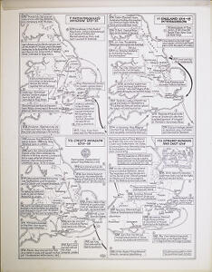
Pièce 20 - Maps of Viking activity during the reign of King Æthelred the Unready, maps V-VIII

Zone d'identification

Cote

Add. VM/C/9/20

Titre

Maps of Viking activity during the reign of King Æthelred the Unready, maps V-VIII

Date(s)

  • 2002 (Production)

Niveau de description

Pièce

Étendue matérielle et support

1 map on artist's board, 1 map on tracing paper; 56 x 44 cm and smaller

Zone du contexte

Histoire archivistique

Source immédiate d'acquisition ou de transfert

Zone du contenu et de la structure

Portée et contenu

Four maps on one page: 'V Swein Forkbeard's Invasion 1013-14', 'VI England 1014-15 Intercission', 'VII Cnut's Invasion 1015-16', 'VIII Edmund Ironside and Cnut 1016'. Made in 2002, for general purposes.

Appraisal, destruction and scheduling

Accruals

System of arrangement

Zone des conditions d'accès et d'utilisation

Conditions d’accès

Conditions governing reproduction

Language of material

    Script of material

      Language and script notes

      Caractéristiques matérielle et contraintes techniques

      Finding aids

      Zone des sources complémentaires

      Existence and location of originals

      Existence and location of copies

      Related units of description

      Descriptions associées

      Zone des notes

      Identifiant(s) alternatif(s)

      Mots-clés

      Mots-clés - Sujets

      Mots-clés - Lieux

      Mots-clés - Noms

      Mots-clés - Genre

      Identifiant de la description

      Identifiant du service d'archives

      Rules and/or conventions used

      Statut

      Niveau de détail

      Dates of creation revision deletion

      Langue(s)

        Écriture(s)

          Sources

          Accession area